ABOUT THE PROJECT

This ecosystem mapping project aims to assess mangrove coverage along the entire coastline of Madagascar. Leveraging satellite data, we establish baseline data on mangrove expansion over time and estimate carbon content and stock levels – the so-called “blue carbon”.
Blue carbon refers to carbon captured and stored by coastal and marine ecosystems, in particular by mangroves, seagrasses and salt marshes. These habitats act as natural sinks of carbon, effectively reducing atmospheric CO2 concentrations. In addition to their significant role in climate regulation, they offer a wide range of ecosystem services. They enhance biodiversity, supporting activities like sustaining migratory bird populations, bolstering fisheries, generating revenue through ecotourism. Moreover, they serve as a protective barrier against coastal erosion and extreme weather events.
“Blue carbon” ecosystem are vital for fighting climate change
Despite covering less than 0.5% of the world’s ocean floor, they account for approximately 50% of the carbon stored in oceanic sediment. Recognizing the important role of blue carbon ecosystems, such as mangroves, saltmarshes, and seagrass meadows, in carbon sequestration and storm protection, these environments are vital assets in the fight against climate change. However, these blue carbon ecosystems are facing critical rates of degradation and require immediate action to prevent further loss. When these coastal wetlands deteriorate, they not only cease to capture carbon but can also become substantial emitters of greenhouse gases.
Leveraging Earth Observation (EO) for ecosystem mapping
In recent years, there has been notable advancement in comprehending the elements and mechanisms affecting carbon storage in these ecosystems. However, the task of creating detailed maps and accurately quantifying the primary carbon reservoirs still poses difficulties. This is primarily due to the limited availability of on-site data and uncertainties in the existing data.
EO technologies provide essential tools for the detailed mapping and ongoing monitoring of these ecosystems, facilitating the integration of satellite data with climate models and ground sensors. This integration enables a comprehensive analysis of coastal dynamics, the resilience of coastal vegetation, and the detection of vulnerabilities to future climatic shifts, thus supporting effective conservation and adaptive management measures.
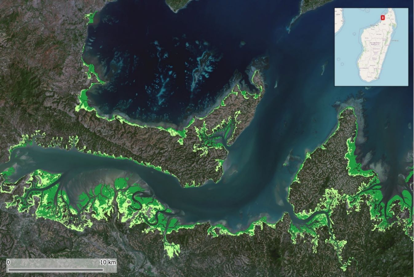
Mapping Madagascar’s mangrove forests
As part of a collaboration with the World Bank and the European Space Agency (ESA), led by the Austrian company GeoVille, we are currently mapping the entire coastline of Madagascar to assess mangrove coverage. This project aims to establish baseline data on mangrove expansion over time and estimate carbon content and stock levels.
Using Sentinel-2 and historical Landsat-5 data, we mapped the extent and distribution of mangroves for the years 2020 (baseline), 2010, and 1996. Above-ground biomass (AGB) was calculated by applying a machine learning method that integrates predictor variables, including spectral indices, elevation, and slope. To support the biomass and canopy height estimates in the absence of in-situ data, we used above-ground biomass density (AGBD) estimates from NASA’s Global Ecosystem Dynamics Investigation (GEDI) mission as reference data. Soil organic carbon was then predicted based on the derived AGBD, Sentinel-2 bands, additional covariate layers, and global soil parameter maps (pH and bulk density) available at 30-meter resolution.
Detailed information on mangrove extent and associated blue carbon potential is being provided to Madagascar’s Ministry of Environment and Sustainable Development and the Ministry of Fisheries and Marine Resources. This data offers critical insights to support ecosystem protection and rehabilitation efforts and to explore future opportunities for the country in the blue carbon market.
More on blue carbon projects by EOMAP
We aim to support efforts to safeguard blue ecosystems worldwide through satellite-based mapping initiatives. Our extensive experience in blue carbon projects includes producing seagrass density maps for the entire coast of Schleswig-Holstein along Germany’s Baltic Sea and further mangrove mapping projects around the globe. Since 2024, EOMAP has also been part of an international consortium dedicated to mapping seagrass meadows along Italy’s entire coastline, one of Europe’s largest habitat mapping project led by the Italian Environmental Agency ISPRA. This mapping provides essential baseline data for future restoration projects, but also for blue carbon assessments.
MEDIA

SUMMARY
ESA GDA FFF of the European Space Agency (ESA), led by GeoVille, involving the World Bank
Ecosystem Mapping
Satellite-Derived Bathymetry, Habitat Mapping, Great Barrier Reef, Corals