ABOUT THE PROJECT
Since 2024, EOMAP has been part of an international consortium dedicated to mapping seagrass meadows along Italy’s entire coastline. This large European habitat mapping project is conducted by the Italian Environmental Agency ISPRA. It provides baseline data for future restoration projects, but can also be used for blue carbon assessments. We contribute by satellite-based measurements of two seagrass species, a key component of the project.
Seagrass ecosystems are vital marine habitats
Seagrass is a small plant with huge impact on ocean health and coastal resilience: Researchers worldwide agree that seagrass meadows count among the most common marine coastal biotopes, and are hotspots for both biodiversity and productivity. (see Article in “nature plants”) .
According to UNEP Copenhagen Climate Centre, seagrasses provide many important services to both ecosystems and humankind on over 300,000 km2 and +150 countries:
– They are nursery habitat and shelter for fish or crustaceans, thus providing food.
– Seagrass meadows are home to fascinating species, such as dugongs, seahorses and sea turtles.
– They function as water purification or carbon storage and weaken storm impacts.
– Seagrass is a sustainable source of renewable raw material and energy.
– Last, but not least, seagrass meadows serve as ecological indicators of water quality and coastal biotopes.
Just like mangroves, salt marshes, seagrass meadows count among the so called “blue carbon” ecosystems. These habitats not only play an underestimated role in carbon sequestration and storm protection. They are also crucial for fighting climate change. Despite covering less than 0.5% of the world’s ocean floor, blue carbon ecosystems account for approximately 50% of the carbon stored in oceanic sediment. However, “blue carbon” ecosystems are facing critical rates of degradation and require immediate action to prevent further loss. When deteriorating, seagrass meadows not only cease to capture carbon, but can also become substantial emitters of greenhouse gases.
Leveraging Earth Observation (EO) for seagrass mapping
To keep these ecosystems healthy, we need to understand their coverage, health status, and development. In recent years, technology has advanced in measuring the expansion of ecosystems, specifying habitats and their health, but also in comprehending mechanisms affecting their carbon storage capacities.
EO technologies provide essential tools for the detailed mapping and ongoing monitoring of these ecosystems. They increasingly facilitate the integration of satellite data with field, lidar or drone data and climate modeling. This allows for a comprehensive analysis of coastal dynamics, the resilience of coastal vegetation, and of vulnerabilities to future climatic shifts. Subsequently, these analysis support effective conservation and adaptive management measures.
Mapping seagrass habitats along Italy’s coastline
In 2024, ISPRA – on behalf of the Italian Ministry for the Environment – kicked off a large scale mapping of coastal and marine habitats along 8,000 kilometers of the Italian coast. A consortium is mapping coastal and marine habitats as part of the “Marine Ecosystem Restoration” (MER) project, from 2024 to 2026. Special focus is being given to Marine Protected Areas (MPAs) and Natura2000 sites.
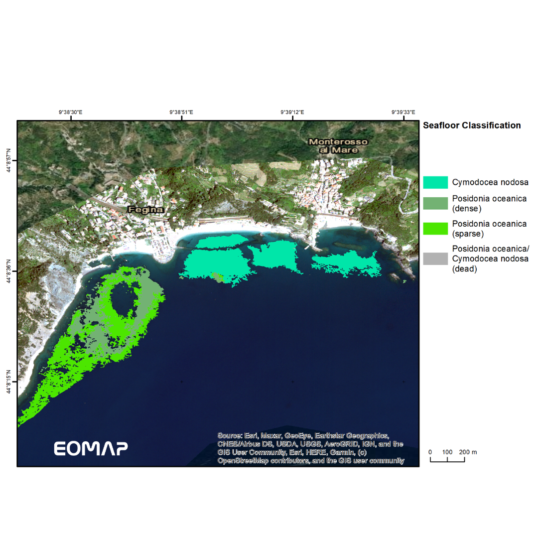
EOMAP – as a partner for this project consortium led by Fugro – contributes to this farsighted endeavour by mapping habitats of Posidonia oceanica and Cymodocea nodosa from Space. These satellite-based measurements are a key component of the project. Along with satellite-based mapping and monitoring seagrass meadows we provide
- Spatio-temporal information which refers to seagrass and defines both its biomass build-up and health.
- These include ongoing analysis on water clarity and eutrophication and seabed parameters (using eoapp AQUA)
- as well as sediment dynamics on the seabed (using eoapp SDB-Online).
More on ecosystem mapping projects by EOMAP
We aim to support efforts to safeguard blue ecosystems worldwide through satellite-based mapping initiatives. Our extensive experience in blue carbon projects includes producing seagrass density maps for the entire coast of Schleswig-Holstein along Germany’s Baltic Sea and further mangrove mapping projects around the globe. In 2024, we conducted an ecosystem mapping project to assess mangrove coverage along the entire coastline of Madagascar. Leveraging satellite data, we establish baseline data on mangrove expansion over time and estimate carbon content and stock levels – the so-called “blue carbon“.
Please get in touch with our coastal team or read more on habitat mapping here.
📷 The image (courtesy of Fugro) shows preliminary classification details of two seagrass species we have mapped along the Ligurian coast.
MEDIA

SUMMARY
PlanBlue, EOMAP, consortium led by Fugro
Ecosystem Mapping, Satellite-Derived Bathymetry
Seagrass, Satellite-Derived Bathymetry, Habitat Mapping, Italy