Land Cover

Land cover classification and land use analysis are vital for understanding ecosystem dynamics. They help manage natural resources, develop areas sustainably and mitigate environmental impacts. Thus, EOMAP supports informed decision-making in agriculture, forestry, urban planning, conservation, and climate action.

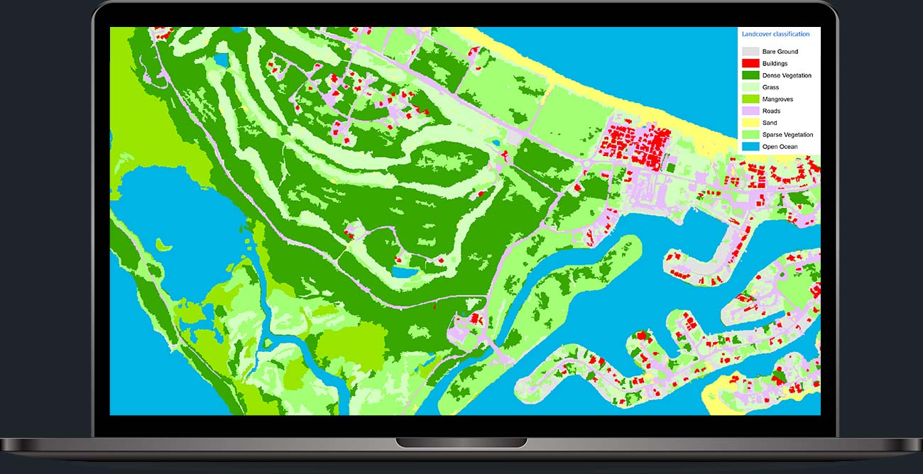
How your result could look

For an in-depth classification of land use, you can count on us using the most appropriate multispectral, optical and radar data. EOMAP services range from rapid identification of single classes to highly complex habitat mapping of vast areas.

Land cover classification: Satellite Image (RGB) of Treasurecay Island Before processing by EOMAPLand cover classification: Satellite-based habitat map of Treasurecay Island by EOMAP

How we classify Land Cover

Count on the expertise of our interdisciplinary team and a multi-step approach. For classifying land use, we pick the most relevant satellite imagery according to the level of detail you desire. If required, we include seafloor classification for seamless maps of coastal areas.

First, we take the time to understand which level of detail and focus your land cover classification requires. Based on your needs, we define a classification scheme and the desired quality of the final dataset. This is followed by pre-processing and object-based classification, before we run calibration and validation.

We then access all satellite imagery that is relevant for your land cover classification. The subsequent pre-processing steps we perform include atmospheric correction and spectral filtering. With these steps, we improve the quality of the thematic classification, which is finally performed by object-based classification procedures.

We use four main characteristics to classify surface objects within the area of land use analysis: The objects’ spectra (colour), shape, texture and their temporal change. For speeding up this thorough qualification and pattern recognition, we can apply Artificial Intelligence (AI).

Once the objects have been classified, we run standardised calibration and validation procedures. These quality control processes provide you with a robust mapping solution. We always keep in mind that this knowledge on land cover serves as a sound basis for your decision-making.

Our products range from 10m and 30m resolution from Sentinel-A/B and Landsat 8, down to 2m and 5m ground sample distance. The latter high level of detail is made available by commercial data providers, such as MAXAR and Airbus.

If needed, we classify both the seafloor and the land cover from space. Both classification datasets – including metadata – can be integrated into one seamless model. This strengthens an in-depth understanding of coastal areas.

Why choose EOMAP’s Land Cover Classification?

Valid results

Make use of a physics-based, validated and stable land cover analysis without stepping foot on the ground. More than 500 clients worldwide trust our solutions and services.

Ahead of time

State-of the art image correction procedures will benefit the precision of your research, planning and modeling work. Such enhanced land cover intelligence will help you thrive and be more competitive.

Time savings

Relying on EOMAP’s land cover classification, you avoid struggling with satellite data access and pre-processing. This gives you more time for your analytics and research.

Seamless datasets

Benefit from EOMAP’s expertise in seafloor classification! Accessing land use and benthic data in an all-in-one dataset will save you valuable time.

More on Land Cover

TECH DEEP DIVE

INFO CENTRE

FAQ

Simply send your area of interest in digital format to our land cover team or use our contact form. You’ll receive appropriate feedback from our experts within 24 hours.

Please hover over the buttons below “Why use EOMAP’s Land Cover Classification” to see why.
In short: Your specific requirements are our guiding line for our classification processes from the very start. Based on these, we select the most relevant satellite data sources and offer the most appropriate approach.

If you are interested in more projects we’ve delivered in your field of interest, please get in touch!

The mapping accuracies typically vary with the detail of the classification schema and classification complexity. Typically, our clients have validated our classification data to be in the range of 85-90% accuracy. This rate can even be increased using on-site validation data.

The default file types of our land classification data are vector shape files, which come with a PDF map and metadata. If you require grids or other formats, we can convert these on request.

Discover our services

In addition to Land Cover Classification, we provide Digital Terrain Models and more complementary services! – Unlock the power of actionable insights from space.