The R&D project REMAP offers interesting insights and new capabilities into how to use multispectral drone data for efficiently mapping very shallow waters. This project has been finalised together with German Aerospace Center (DLR) and OptoPrecision GmbH and in close collaboration with Fugro. The project team developed a flexible drone-based system for surveying coastal and shallow water zones.
Challenging conditions in shallow water
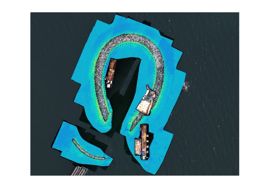
Currently, on-site survey methods for shallow water require substantial effort in equipment and costs. To address this, we developed a concept and system using standard drones. These drones can be operated with standard licenses and equipped with relatively affordable yet precise multispectral sensor systems and positioning tools.
However, this approach presented several challenges. Until now, our physics-based algorithms for retrieving depth and water properties have relied on either multispectral satellite data or hyperspectral airborne data. Factors such as the amount of data collected, recording conditions, precise positioning, and recording below cloud cover, among others, needed to be carefully considered and applied.
The outcome: a streamlined workflow for standard drones
The drone-based system now offers a streamlined workflow with user-friendly operation. It enables flexible on-site surveys at very high resolution, which is especially valuable for mapping changes such as coastal erosion processes and for benthic studies.
Key insights from the REMAP project include:
- Multispectral drone data are particularly effective in very shallow waters.
- Proper calibration, data analysis, mosaicking, and geolocation improvements are crucial.
- Throughout the project, the developed algorithms and workflows proved reliable across different sites and with three different sensors.
Coastal stakeholders will benefit from flexible and extremely high-resolution bathymetric data, which enhances decision making. This should be complemented by seafloor characterisation to help detect localised anomalies in shallow water areas, which are critical for navigation or coastal engineering projects.
We appreciate the support given by Landesbetrieb für Küstenschutz, Nationalpark und Meeresschutz Schleswig-Holstein and Staatliches Amt für Landwirtschaft und Umwelt Mittleres Mecklenburg.
- For more details, please get in touch with our shallow water team.
Images

Short & Sweet
REMAP is a cooperation project developing a new cost-efficient concept for drone-based mapping in very high resolution (VHR). Within the project, we developped a user-friendly workflow using standard drones for VHR on-site surveys. This can benefit stakeholders in navigation or coastal engineering with flexible and high-res bathymetric data for their coastal change surveys or benthic studies.
Place & Time
Germany, 2022 – 2024
Clients & Partners
OptoPrecision GmbH, German Aerospace Centre (DLR), Fugro
Related Use Cases
SmartCoast – Mangrove mapping in Australia
Water monitoring along the Zambezi
Advice4COASTS
Snowpower
Impact factors of oxygen loss on Elbe River
COASTS – Coastal resilience and blue carbon
Blue carbon – Mangrove mapping in Madagascar
Seagrass Mapping in Italy
4S project – SDB mapping worldwide
3D live habitats for the full extent of the Great Barrier Reef
