
Milestone #7: Launching the world’s first comprehensive global water quality atlas with UNESCO.
Turning satellite data into the world’s first global tool for tracking water quality
Water pollution threatens human health, food supply, and economies. What’s more, global warming and increased consumption intensify the water stress. Yet many regions still lack the monitoring to catch water quality problems early.
That’s where UNESCO’s International Initiative on Water Quality (IIWQ) came in. The goal: building capacity and knowledge-sharing on water quality.
In January 2018, at UNESCO Headquarters in Paris, EOMAP launched the IIWQ World Water Quality Portal. It was the world’s first global water quality portal built entirely on satellite data. Alongside it ran the exhibition “Satellite-based Water Quality Monitoring”.
Dr. Thomas Heege, General Director of EOMAP – a Fugro Company, on why this mattered: “Remote sensing is an efficient and cost-effective tool to assess a variety of physical and biological parameters in aquatic ecosystems over small-scaled and large areas.”
The portal provided information on turbidity, chlorophyll-a, suspended matter, and an indicator of harmful algae blooms for any water body worldwide. In addition, it included near real-time updates and historic time series reaching back up to 30 years, which was highly innovative at the time.
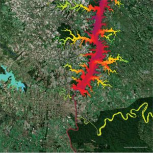
Turbidity mapping of the Itaipu Reservoir, Brazil, provided by EOMAP in 2018 | UNESCO World Water Quality Portal
The mission didn’t stop there
In 2024, we advanced the technology in eoapp AQUA, our next generation solution for water quality monitoring.
Learn More
Learn more about the eoapp AQUA
Note: the IIWQ World Water Quality Portal is no longer accessible online. However, if you are interested in gaining a glimpse into the data set, simply get in touch with us via wq@eomap.de
Follow along and share your memories in the comments as we look back on two decades of progress, collaboration, and impact!

Latest EOMAP News

Reuters bases Mekong article on EOMAP data
The Development of EOMAP’s Water Quality Platform

UNESCO Water Quality Portal launched

Launching the world’s first comprehensive global water quality atlas with UNESCO

Oman Oil Spill: SDB Mapping of Critical Shallow Waters for Safe Salvage

eoapp DIVE unterstützt die Tauchplanung
Related Posts
09 / 2026
The Development of EOMAP’s Water Quality Platform
09 / 2026
UNESCO Water Quality Portal launched

08 / 2026
eoapp DIVE unterstützt die Tauchplanung
06 / 2026
Dredge plume monitoring using satellite-based turbidity mapping
04 / 2026
Advocating for Healthy Mountain Ecosystems
04 / 2026
Environmental monitoring for sporting events

04 / 2026
20 Years EOMAP: Advancing Earth Observation
03 / 2026
New BD & Sales Manager for the Americas
03 / 2026
Quick Facts: Lake Eyre

02 / 2026

