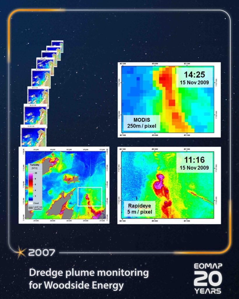
Milestone #4: Large-scale dredging monitoring using satellite-based turbidity mapping.
In 2007, Woodside energy required a reliable water quality monitoring approach to meet environmental regulations. The area in Northwest Australia covered around 1.000 square kilometers of coastal waters. Turbidity maps were created from Satellite data delivered regularly by EOMAP on average every two days, over more then two years using physics-based algorithms.
The goal of the project was to establish a reliable, regular large-scale turbidity monitoring system for pipeline related dredging operations.
A key objective was to track and quantify dredge plumes consistently over time and monitor their proximity to environmental sensitive areas. Traditional methods, such as in situ, only provided point-based measurements and Airborne monitoring would have resulted in substantially increased costs.
 For the first time, this project demonstrated that satellite-based turbidity mapping can support large-scale dredging operations in the Oil & Gas industry.
- More than 430 satellite-derived water quality data sets were delivered, covering an area of 1.000 square kilometers over a period of approximately two years.
- The main spatial resolution was delivered at 250 meters, but various other data sets with up to 3m spatial resolution were utilized for independent verification and monitoring of two records a day.
- Continuous mapping enabled accurate tracking of turbidity patterns to support environmental monitoring and decision-making at a high frequency interval.
“With the professional support from EOMAP and a fast-tracked delivery of daily satellite products the governmental monitoring obligations could be fulfilled and created a first in Australia for such operational use in the Oil & Gas industry.” says Dr. Peter Hausknecht, former chairman of the IOGP Earth Observation subcommittee and SME for remote sensing at Woodside Energy at the time.
With that, the project proved that large-scale, non-invasive monitoring can be both reliable and cost-effective.
Learn More
Learn more about this project.
For further details, refer to the Presentation from Dr. Peter Hausknecht at the OGP Remote Sensing workshop held at ESA.
Follow along and share your memories in the comments as we look back on two decades of progress, collaboration, and impact!
Latest EOMAP News

Reuters bases Mekong article on EOMAP data

UKHO’s highest-ranked Satellite-Derived Bathymetry provider in 2015

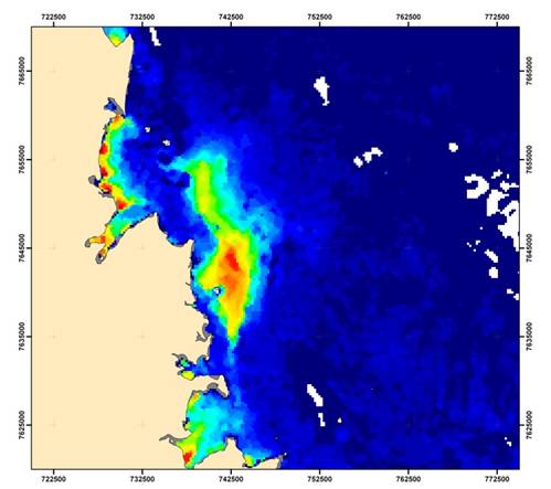
Dredge plume monitoring using satellite-based turbidity mapping

Pioneering seagrass mapping at the Italian coastline in 2006

Mapping Ningaloo Reef 2009: A Breakthrough in Hyperspectral Marine Habitat Analysis

Advocating for Healthy Mountain Ecosystems
Related Posts

04 / 2026
Advocating for Healthy Mountain Ecosystems

04 / 2026
Environmental monitoring for sporting events

04 / 2026
20 Years EOMAP: Advancing Earth Observation

03 / 2026
New BD & Sales Manager for the Americas

03 / 2026
Quick Facts: Lake Eyre

02 / 2026
Quick Facts: Ancient Lakes

01 / 2026
Space-based Intelligence for Clean Energy

01 / 2026
Pro-active hydropower management in winter

12 / 2025
From Climate to Nature and Biodiversity: Insights on COP30

12 / 2025
