YellowScan, a global provider of UAV LiDAR mapping solutions, has added EOMAP’s satellite-derived services to its YellowScan Access ecosystem. Customers now get information on their survey area before deploying equipment, so they can plan projects more efficiently and with greater confidence.
YellowScan Access gives organisations flexible access to professional LiDAR technology. For their bathymetry surveys, customers can rent high-performance systems including hardware, software, technical support, insurance and training.
Satellite imagery contributes to efficient LiDAR surveys
With EOMAP’s satellite-derived environmental analysis now part of the ecosystem, customers can also
- assess the water quality of a site in advance
- recognise opportunities and challenges for airborne LiDAR bathymetry (ALB) mapping early,
- and optimise survey planning before mobilising personnel and equipment.
Water clarity details to optimise LiDAR mapping
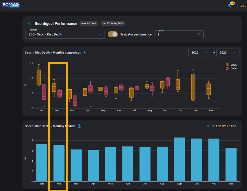
From satellite imagery to monthly Secchi depth monitoring. Highlighted values show two Secchi depths in February for the Bourdigou estuary site.
“Well in advance of mobilisation, EOMAP’s satellite-derived data informs customers about the expected water clarity at a survey site throughout the year. They can therefore plan their LiDAR campaign for the time with the best expected conditions. Making this tool available through YellowScan Access helps customers to plan and conduct their surveys successfully.” explains Philipp Bauer, Product Owner of eoappTM AQUALITE at EOMAP.
Learn More
- Access YellowScan’s story about the Bourdigou use case here
- Contact Philipp of our water quality team for a short demo.
Latest EOMAP News

Reuters bases Mekong article on EOMAP data

YellowScan integrates EOMAP’s services into LiDAR mapping solution

So machen Tourismusregionen saubere Gewässer sichtbar

Blaualgen per Satellit: Jede Badestelle im Blick
The Development of EOMAP’s Water Quality Platform

Launching the world’s first comprehensive global water quality atlas with UNESCO
Related Posts
10 / 2026
So machen Tourismusregionen saubere Gewässer sichtbar
09 / 2026
Blaualgen per Satellit: Jede Badestelle im Blick
09 / 2026
The Development of EOMAP’s Water Quality Platform

08 / 2026
Launching the world’s first comprehensive global water quality atlas with UNESCO
08 / 2026
Oman Oil Spill: SDB Mapping of Critical Shallow Waters for Safe Salvage
08 / 2026
eoapp DIVE unterstützt die Tauchplanung

07 / 2026
UKHO’s highest-ranked Satellite-Derived Bathymetry provider
06 / 2026
Mapping the ‘unmappable’ Great Barrier Reef
06 / 2026
Dredge plume monitoring using satellite-based turbidity mapping
04 / 2026