In SmartCoast, James Cook University, EOMAP, and Fugro collaborated to develop a coastal management digital twin pilot in Torres Strait, Queensland. Through mangrove managing and monitoring, this project focused on increasing resilience to the impacts of climate change and sea level rise. It utilized satellite EO-LiDAR data fusion to provide accurate baseline data and cost-effective monitoring solutions.
Our contributions include developing methods to detect mangroves, estimating mangrove carbon sequestration for Blue Carbon efforts via canopy height modelling, and monitoring shoreline ecosystem changes.
Mangroves are vital coastal habitats
Mangroves are unique trees and shrubs with a significant impact on coastal health and resilience. Researchers worldwide agree that mangrove forests are among the most productive and biologically complex ecosystems on Earth.
According to the Smithsonian Ocean Portal, mangroves provide many important services to both ecosystems and humankind across approximately 138,000 to 200,000 square kilometers globally:
- They serve as nursery habitats and shelter for fish and crustaceans, thus providing food.
- Mangrove forests are home to fascinating species, such as mudskippers, mangrove snakes, and various bird species.
- They function as water purifiers, carbon storage, and protect shorelines from storm impacts.
- Additionally, mangrove forests serve as ecological indicators of coastal health and water quality.
Carbon storage and storm protection
Mangrove forests, along with seagrasses and salt marshes, are integral components of ‘blue carbon’ ecosystems. These environments are vital for carbon storage and storm protection. Blue carbon ecosystems are responsible for about 50% of the carbon stored in coastal sediments. Unfortunately, they are experiencing significant degradation and need urgent measures to prevent further damage.
Utilising Earth Observation (EO) for mangrove mapping
Maintaining the health of mangrove ecosystems requires a thorough understanding of their distribution, condition, and growth patterns. Recent technological advancements have enhanced our ability to measure ecosystem expansion, identify specific habitats, assess their health, and understand factors influencing their carbon storage capabilities.
EO technologies are invaluable for detailed mapping and continuous monitoring of these ecosystems. They enable the integration of satellite imagery with data from field surveys, lidar, drones, and climate models. This integration allows for a comprehensive analysis of coastal dynamics, the resilience of mangrove vegetation, and vulnerabilities to future climate changes. These insights are crucial for supporting effective conservation strategies and adaptive management practices.
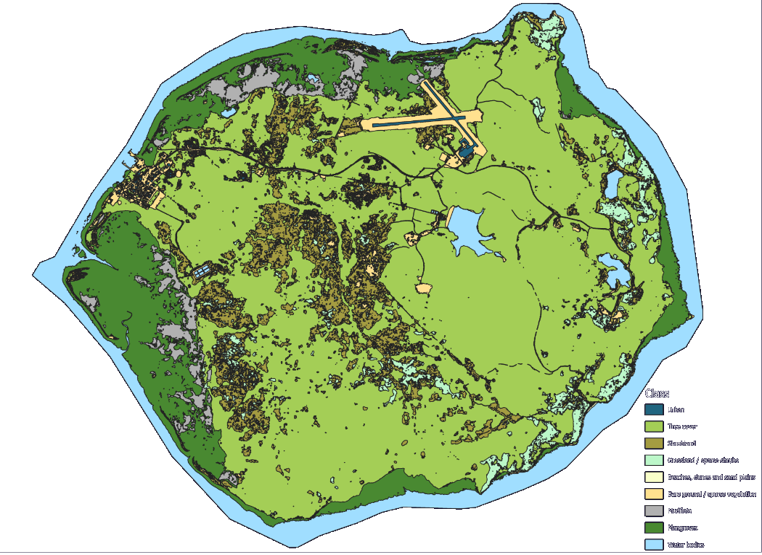
Mangrove habitats on Horn Island, Australia
In 2024, a large-scale project was initiated to map coastal and marine habitats on Horn Island, Australia. This project focused on the detailed mapping of mangrove ecosystems around the entire island.
EOMAP, as a partner in this project consortium led by Fugro, contributes to this ambitious endeavor by mapping mangrove habitats from space. These satellite-based measurements are a crucial component of the project allowing for the creation of a digital twin. Along with satellite-based mapping and monitoring of mangrove forests, we provide:
- Spatio-temporal information that defines both the biomass build-up and health of mangroves, using elevation modelling to determine canopy height.
- Ongoing analysis of indicators of vegetation health, including NDVI.
- Insights into landcover of the island, allowing for a detail analysis of mangrove distribution.
More on ecosystem mapping projects by EOMAP
We aim to support efforts to safeguard blue ecosystems worldwide through satellite-based mapping initiatives. Our extensive experience in blue carbon projects includes producing mangrove density maps for various regions, including Madagascar, Egypt, Djibouti and Yemen. Leveraging satellite data, we establish baseline data on mangrove expansion over time and estimate carbon content and stock levels – the so-called “blue carbon.”
Let’s connect
Learn more about the mapping and monitoring of blue carbon ecosystems.
Here is more on EO Applications for Environment and Resources.
For more details, please contact our coastal team.
Images

Short & Sweet
SmartCoast was a collaborative project, aiming to develop a coastal management digital twin in Torres Strait, Queensland. The project focused on mangroves to manage the impacts of climate change and rising sea levels. It utilises satellite EO-LiDAR data fusion to map and monitor mangrove ecosystems.
Place & Time
Australia, 2024
Partners
James Cook University, Fugro
Related Use Cases
Advice4COASTS
Kelp monitoring in Los Angeles ports
REMAP – a new workflow for drone mapping
Impact factors of oxygen loss on Elbe River
COASTS – Coastal resilience and blue carbon
Blue carbon – Mangrove mapping in Madagascar
Seagrass Mapping in Italy
4S project – SDB mapping worldwide
3D live habitats for the full extent of the Great Barrier Reef
Archipelago of Tonga
