
By beginning of december 2015, ESA opened the data access for its Sentinel 2-A mission. The satellite now is continously recording and data can be accessed via ESA’s Scientific Data Hub. EOMAP already showed first results of its Sentinel 2-A water quality processor earlier, based on an image from Lake Garda/Italy, one of the first available datasets during the commissioning phase.
Now, as the mission entered the operational phase a few weeks ago, both, EOMAP’s water quality as well as bathymetry processors, are fully prepared to provide value added products from the latest addition to ESA’s Copernicus program.
With a native spatial resolution of up to 10m, the data offers an unprecendented amount of detail when it comes to free-of-charge satellite raw data.
Figure 1 shows a 3D bathymetric modell of Capricorn Reef Group/Great Barrier Reef, Australia, derived from Sentinel 2-A data recorded on January 1st 2016. The reef group is part of the Capricornia Cays National Park and is one of the southernmost reef groups of the entire Great Barrier Reef. Subsurface reflectance data, corrected for atmospheric effects as well as effects of the water surface, was draped upon the 3D modell:
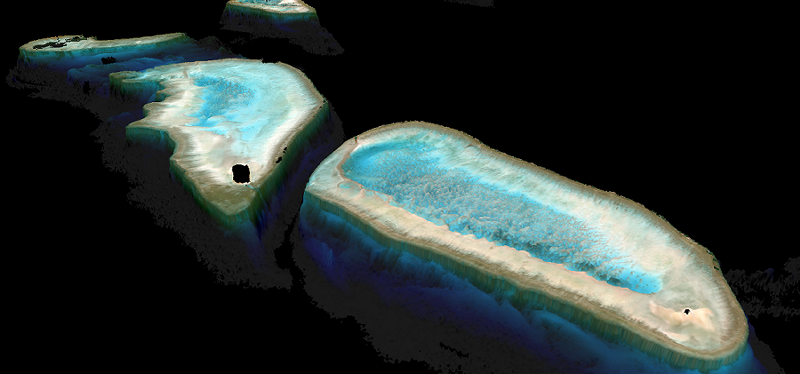
Sentinel 2-A derived 3D bathymetric modell of Capricorn Reef Group, Australia
Output from EOMAP’s Sentinel 2 water quality processor is showcased in figure 2. The image shows turbidity distributions in a small area of the Mississippi River estuary, one of the continent’s most valuable wet land ecosystems. It is a subset of the article’s title image. The image was recorded on January 4th 2015:
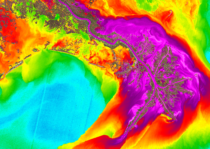
Sentinel 2-A derived turbidity product, Mississippi Delta

Latest EOMAP News

Reuters bases Mekong article on EOMAP data
The Development of EOMAP’s Water Quality Platform

UNESCO Water Quality Portal launched

Launching the world’s first comprehensive global water quality atlas with UNESCO

Oman Oil Spill: SDB Mapping of Critical Shallow Waters for Safe Salvage

eoapp DIVE unterstützt die Tauchplanung
Related Posts
09 / 2026
The Development of EOMAP’s Water Quality Platform
09 / 2026
UNESCO Water Quality Portal launched

08 / 2026
Launching the world’s first comprehensive global water quality atlas with UNESCO
08 / 2026
Oman Oil Spill: SDB Mapping of Critical Shallow Waters for Safe Salvage

08 / 2026
eoapp DIVE unterstützt die Tauchplanung

07 / 2026
UKHO’s highest-ranked Satellite-Derived Bathymetry provider

06 / 2026
Mapping the ‘unmappable’ Great Barrier Reef
06 / 2026
Dredge plume monitoring using satellite-based turbidity mapping

04 / 2026
Ningaloo Reef 2009: Hyperspectral Marine Habitat Mapping
04 / 2026

