Hydrographic offices and navies must navigate rising operational demands while maintaining the highest standards of safety and precision. At the same time, the need for fast, data‑driven insights is growing, calling for efficient and robust methods.
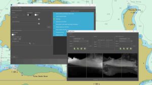 With WATCOR‑X, authorities can derive shallow‑water bathymetry accurately, securely, and on demand. It empowers users to generate high‑resolution bathymetric grids anywhere on the globe, without the need for site‑specific calibration data.
The new WATCOR-X subpage offers a detailed overview of the capabilities, including key features, processing insights, and real‑world advantages for operational users.
For a closer look at WATCOR‑X in action, we also provide a series of explanatory tutorials on YouTube. These step‑by‑step videos demonstrate key functions, workflows, and use cases – helping new users quickly understand what the software can do.
Contact shallowwater@eomap.com for further details.

Latest EOMAP News

Reuters bases Mekong article on EOMAP data

WATCOR‑X Bathymetry Software for Navies and Hydrographic Offices

Quick Facts: Ancient Lakes

Space-based Intelligence for Clean Energy
Bathymetry in the Gulf of Mexico

Pro-active hydropower management in winter
Related Posts

01 / 2026
Bathymetry in the Gulf of Mexico

01 / 2026
Pro-active hydropower management in winter

11 / 2025
Italian Webinar: Water Quality Monitoring from Space

10 / 2025
SDB Update #9 – Validation and Accuracy

10 / 2025
New Storymap: Bathing Water Monitoring from Space

10 / 2025
SDB Update #8 – Multisource Bathymetry

08 / 2025
SDB Update #7 – Topobathy of the Red Sea

07 / 2025
SDB Update #6 – Satellite-based Topobathy Models

07 / 2025
SDB Update #5 – Storymap on Satellite-Derived Bathymetry

06 / 2025
