Iran’s water crisis is a wake-up call. We have looked at the extent of the drama from space to see what we can learn for the future. Above all, we hope the people of Iran will soon be blessed with rainfall.
Iran is facing the toughest drought in recent history, and Tehran could run out of water within weeks. Entire communities may face evacuation.
Not just an Iranian problem
The crisis shows how climate change, overuse by agriculture, industry, and swelling urban populations can push water systems to the brink. Water stress is escalating worldwide, including here in Europe. Recently, the UN has found ‘water crisis’ or ‘water stress’ no longer appropriate for many cases. This is why the UN University’s Institute for Water, Environment and Health – the UN’s Think Tank on water – titled its latest report published in January 2026 “Global Water Bankruptcy Report”.
Monitoring aquatic environments is not a cure-all, yet can enable data-driven and timely action. However, traditional monitoring methods often fail to provide timely, basin-wide insights, leaving policymakers and businesses blind to emerging risks.
Enhancing water governance
Just as we cannot provoke rainfall, there is actionable information we can provide to water managers. Space-based monitoring can significantly improve water governance by offering the following:
- Real-time visibility of water levels and quality across vast regions
- Seasonal and long-term trends of water levels and quality
- Early warning systems for droughts, floods, and pollution events
- Data-driven decision-making for agriculture, industry, and urban planning
Satellite technology to anticipate crisis
Space-based monitoring is also about resilience. By integrating satellite data with field and ground data, authorities can anticipate crises before they spiral out of control, safeguard ecosystems, and ensure water security.
Use cases across the world
In projects like ESA’s Global Development Assistance (GDA) Water, we are already delivering actionable insights for rivers and lakes worldwide. These include the Zambezi Basin, the Mekong Delta, or the Elbe River. Moreover, we track volume changes in reservoirs, chlorophyll surges, reveal turbidity, and support emergency responses to algal blooms in many other projects.
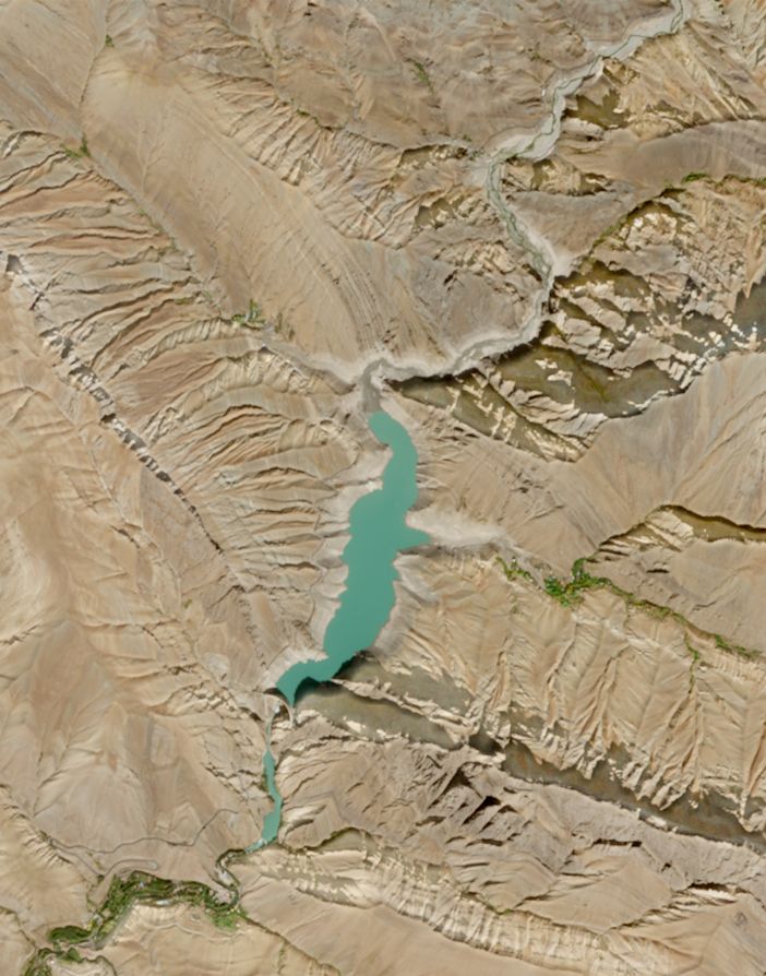
ESA’s Copernicus Sentinel-2 images below show the Amir Kabir Dam, around 60 km northwest of Tehran. The comparison unveils the drastic water loss leading to the crisis. According to Reuters quoted in this article by CNN, the reservoir was only 8% full in early December 2025.

The Amir-Kabir reservoir northwest of Tehran captured by ESA’s Sentinel-2 in October 2021

The Amir-Kabir reservoir captured by ESA’s Sentinel-2 in October 2025, when the crisis emerged
Let’s connect
Check out more use cases here.
For more details, please get in touch with the water quality team.
Learn more about our river-focused solutions.
Latest EOMAP News


Related Posts

03 / 2026
New BD & Sales Manager for the Americas

03 / 2026
Quick Facts: Lake Eyre

02 / 2026
Quick Facts: Ancient Lakes

01 / 2026
Space-based Intelligence for Clean Energy

01 / 2026
Bathymetry in the Gulf of Mexico

01 / 2026
Pro-active hydropower management in winter

12 / 2025
From Climate to Nature and Biodiversity: Insights on COP30

11 / 2025
Italian Webinar: Water Quality Monitoring from Space

11 / 2025
Projektstart SEAGUARD

10 / 2025
