Bathymetry Service Platform Provides Innovative Service
Large areas of our seas and oceans are inadequately surveyed. With the rise of the Blue Economy there is an increasing demand for data, yet there are not the resources to produce it cost effectively using traditional hydrographic survey methods.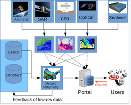
Earth Observation (EO) data is an innovative, rapid and cost effective approach to determine bathymetry from space.
The EU-project BASE Platform (Bathymetry Service Platform) provides easy online access to up-to-date, high resolution global satellite-based information on the topography of the ocean floor (bathymetry).
Information on water depth is one of the most important parameters for monitoring and measuring environmental changes in the coastal zone or shallow off-shore areas. For marine navigation, port and offshore construction, security, fishing industry and coastal zone management it is essential to access up-to-date bathymetric data on a global scale.
The BASE Platform focuses on Satellite Derived Bathymetry and combines it with tidal modeling and crowd sourced data collection techniques for improved accuracy. These innovative remote sensing techniques are able to detect subsea surface and measure depth with an exceptional level of accuracy. Crowd sourcing is also key: Vessels chip in valuable data by recording depth soundings as they navigate.
The BASE Platform is a network of EU research institutes and private companies and funded by the EU Horizon 2020 research and innovation program.
Online workshop – 14 September 2017
The BASE Platform organizes its next webinar.
Thursday, 14th September 2017, 2pm – 3:30pm (CEST)
The online webinar will be streamed live on YouTube. You will learn about space bathymetry, watch a demonstration of the portal and the integration into common GIS software. There is also the opportunity to ask questions during the workshop.
Latest EOMAP News


Related Posts

03 / 2026
New BD & Sales Manager for the Americas

02 / 2026
WATCOR‑X Bathymetry Software for Navies and Hydrographic Offices

01 / 2026
Bathymetry in the Gulf of Mexico

01 / 2026
Pro-active hydropower management in winter

12 / 2025
A short recap of 2025

12 / 2025
From Climate to Nature and Biodiversity: Insights on COP30

11 / 2025
Italian Webinar: Water Quality Monitoring from Space

11 / 2025
Projektstart SEAGUARD

10 / 2025
SDB Update #9 – Validation and Accuracy

10 / 2025
