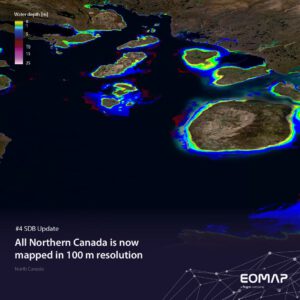
SDB Update No. 4 takes us to the high latitudes of Northern Canada, which we have now mapped in 100 m resolution. The longest national coastline worldwide is an impressive showcase for Satellite-Derived Bathymetry (SDB). This post shows the value of SDB for such remote and extensive areas.
The coasts of North Canada are a challenge for traditional surveying
Canada’s coastline measures up to 243,000 km in length! Moreover, the Canadian coastal morphology is incredibly diverse owing to its vast size, glacial history, tectonic activity, and its interactions with multiple oceans including the Atlantic, Pacific, and Arctic Oceans. In the Northern part of the coast touching the Arctic Ocean, permafrost, sea ice, fjords, and deltas in low-lying tundra regions dominate the landscape. This also results in shallow lagoons and thousands of islands of various sizes .
Hence, these remote regions with tough environmental conditions and high tidal dynamics were among the last to be charted. You might recall the famous and tragic Franklin’s lost expedition, an attempt to collect ancillary navigation data across the last untraversed sections in the Canadian Arctic.
SDB Update North Canada
Mapping North Canada – an opportunity for satellite data
Thus, many of the Canadian Arctic Coastal regions – except for highly frequented navigation channels – are subject to navigation hazards. These include changing shallow water zones, shoals, and rocks.
This concern led to a fascinating use case under the Canadian Ocean Protection Plan: The Canadian Hydrographic Service engaged with indigenous coastal communities to bring more safety to their marine activities. Read about how our SDB data was used by the Inukjuak community for planning and de-risking a mapping project. For even more details on the technologies applied, read this paper in the International Hydrographic Review.
To derive the above mentioned 100-m bathymetry dataset on the entire Canadian Arctic Archipelago, we used optical Copernicus Sentinel-3 imagery. This is helpful for:
⚓ Gaining information on inaccessible locations
🔭 Reconnaissance for more detailed in-situ bathymetric surveys
🌊 Low-effort data collection for dynamic hydrography
Of course, we can also provide SDB products in very high resolution.
Contact
For other purposes, such as coastal engineering and planning we can increase the spatial resolution of SDB grids to sub-metre levels of detail. – Interested?
Please contact shallowwater@eomap.de for SDB services in Canada and worldwide.
SDB update is a Linkedin post series on Satellite-Derived Bathymetry (SDB) by EOMAP – a Fugro company. Enjoy news, facts, and figures on a bi-weekly basis!

Latest EOMAP News


Related Posts

02 / 2026
WATCOR‑X Bathymetry Software for Navies and Hydrographic Offices

01 / 2026
Bathymetry in the Gulf of Mexico

12 / 2025
From Climate to Nature and Biodiversity: Insights on COP30

10 / 2025
SDB Update #9 – Validation and Accuracy

10 / 2025
New Storymap: Bathing Water Monitoring from Space

10 / 2025
SDB Update #8 – Multisource Bathymetry

08 / 2025
SDB Update #7 – Topobathy of the Red Sea

07 / 2025
SDB Update #6 – Satellite-based Topobathy Models

07 / 2025
SDB Update #5 – Storymap on Satellite-Derived Bathymetry

06 / 2025
