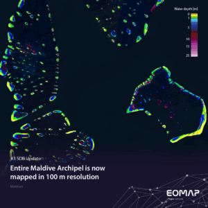
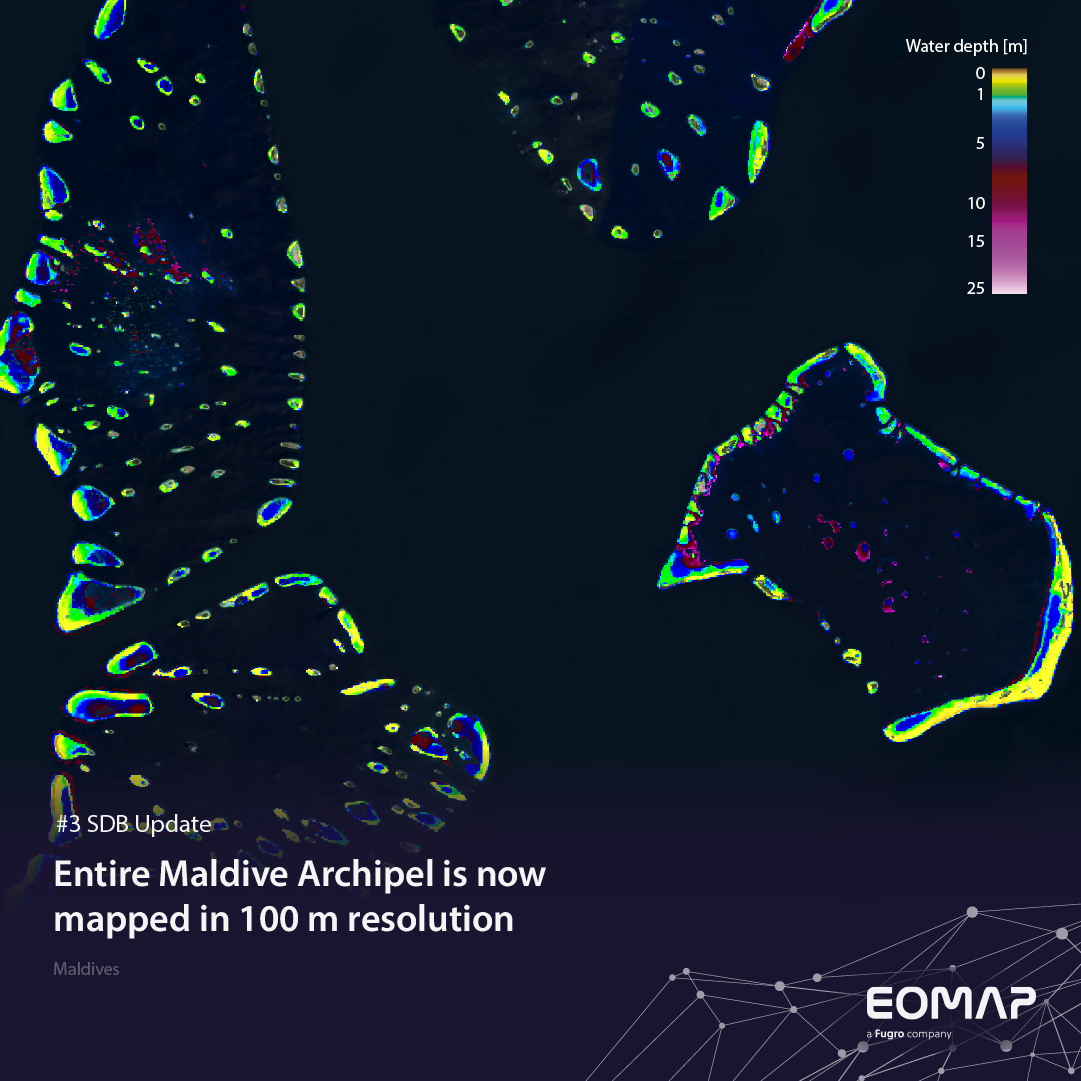
SDB Update No. 3 takes us to the lowest-lying country*) in the world: The Maldives. Only recently, we have mapped Asia’s smallest country in a resolution of 100 m! – This post shows how Satellite-Derived Bathymetry can benefit such widely uncharted shallow waters.
*) in average elevation
1,200 islands slightly above sea level
The Maldives archipelago consists of about 1,200 small coral islands or sandbanks, clustered in 26 atolls of volcanic origin. None of these islands in the Indian Ocean rises to more than 1.8 metres above sea level.
Like the Bahamas (see SDB Update 2), the Maldives is highly attractive to tourists, welcoming 1.5 million people per year. Yet, the inhabitants of the Maldives are not only aware of the beauty of their islands, but also of their vulnerability.
In this context, the Maldives spearheads a group of small islands and low-lying coastal countries that face unique environmental challenges, especially related to climate change: the Alliance of Small Island States (AOSIS) and Small Islands Development States (SIDS). Their concerns will be addressed at the UN Ocean Conference 2025 in France, where our colleague Mona Reithmeier will join a panel about “Powering Progress: Data, Skills, and Technology for the Ocean” on 11 June.
Largely unmapped with ideal conditions for SDB
In fact, 99% of the Maldives Republic’s territory is made up of the sea. However, most of the shallow waters there have not been mapped so far. The turquoise ponds around the often tiny islands offer high water clarity and ideal conditions for SDB.
SDB is a sound basis for understanding the Maldives’ shallow waters. It supports
- the understanding of coastal dynamics, human impact and vulnerability
- hydrodynamic modelling and resilience measures
- protecting this unique island ecosystem and sustainably managing near-shore activities
More EOMAP activities in the Maldives
>> Coastal resilience: The Maldives are one of the pilot regions of the COASTS project. In collaboration with Maldives Space Research Organisation (MSRO), Fugro, and Submaris we create an online solution for coastal stakeholders.
>> Sea level rise: The Maldives app, which we developed for the World Bank in the framework of an ESA project on the impacts of sea level rise.
> Coastal protection, free navigable channels: In 2018, Van Oord used our SDB data to manage dredging activities in a protected area of the Maldives.
Contact
For other purposes – especially in coastal engineering and planning – we can increase the spatial resolution of SDB grids to submeter levels of detail. – Interested?
Please contact shallowwater@eomap.de for SDB services in the Maldives and worldwide.
SDB update is a Linkedin post series on Satellite-Derived Bathymetry (SDB) by EOMAP. Enjoy news, facts, and figures on a bi-weekly basis!
Latest EOMAP News

Reuters bases Mekong article on EOMAP data

UKHO’s highest-ranked Satellite-Derived Bathymetry provider in 2015

Mapping the ‘unmappable’ Great Barrier Reef

Dredge plume monitoring using satellite-based turbidity mapping

Pioneering seagrass mapping at the Italian coastline in 2006

Mapping Ningaloo Reef 2009: A Breakthrough in Hyperspectral Marine Habitat Analysis
Related Posts

07 / 2026
UKHO’s highest-ranked Satellite-Derived Bathymetry provider in 2015

06 / 2026
Mapping the ‘unmappable’ Great Barrier Reef

05 / 2026
Pioneering seagrass mapping at the Italian coastline in 2006

04 / 2026
Mapping Ningaloo Reef 2009: A Breakthrough in Hyperspectral Marine Habitat Analysis

04 / 2026
Advocating for Healthy Mountain Ecosystems

04 / 2026
Environmental monitoring for sporting events

04 / 2026
20 Years EOMAP: Advancing Earth Observation

03 / 2026
New BD & Sales Manager for the Americas

03 / 2026
Quick Facts: Lake Eyre

02 / 2026
