Milestone #3: Back in 2006, EOMAP secured the first commercial contract for satellite-based seagrass mapping in the Brindisi region, together with ILF.
Mapping Posidonia oceanica
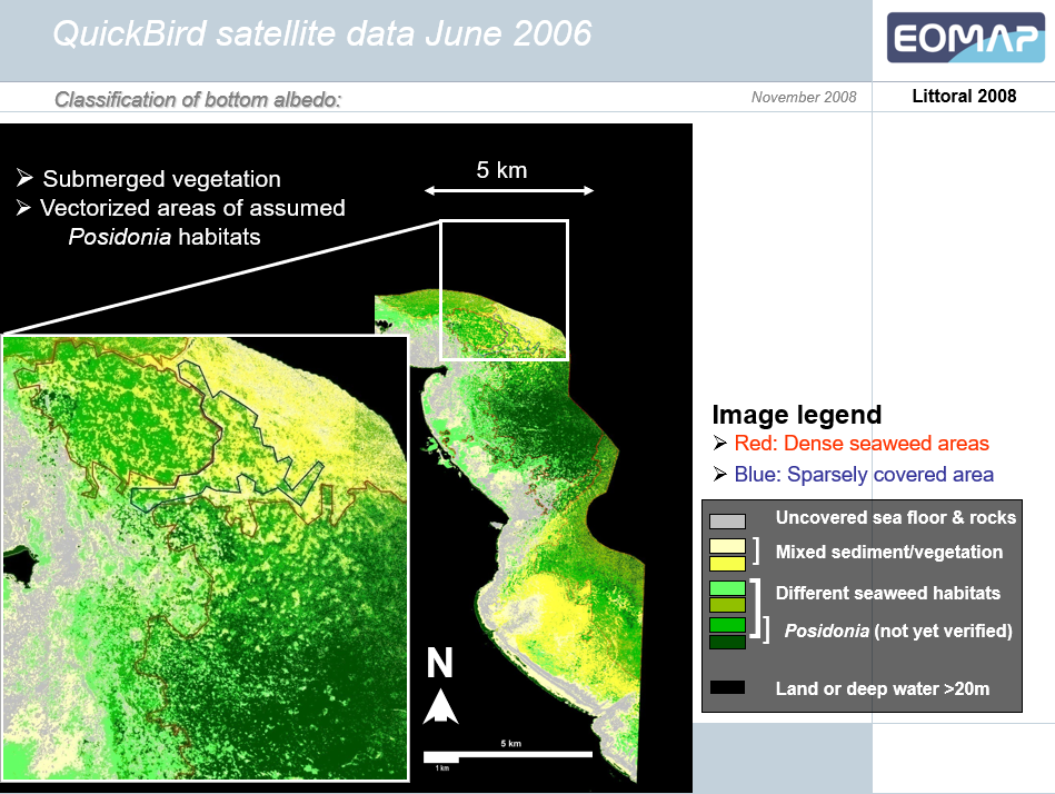
The focus was on Posidonia oceanica, a vital and protected seagrass species endemic to the Mediterranean. These underwater meadows play a crucial role in marine ecosystems and carbon sequestration.
For the planning of the Trans Adriatic Pipeline at that time, obtaining reliable data for environmentally responsible routing was essential. However, traditional seafloor mapping methods, such as ship-based surveys, are time-consuming and involve high costs.
Brindisi Seafloor Mapping using QuickBird Satellite Data | 2006
Pioneering Satellite-Based Seafloor Mapping
This pilot project marked a major breakthrough. For the first time, high-resolution satellite data mapped seagrass habitats reliably. The project proved that non-invasive, scalable mapping from space is possible.
Up to this point, bathymetry was only derived from hyperspectral airborne data. This project showed that bathymetry data can also be derived from satellites. In addition, it marked the extension of EOMAP’s physics-based approach to include multispectral satellite data.
From Pilot Project to National Scale
What started in Brindisi has grown into a national-scale initiative across 8,000 km of the Italian coastline. Since 2024, Fugro and we have been part of an international consortium led by ISPRA, the Italian Institute for Environmental Protection and Research. This time, we provide satellite-based mapping of key seagrass species to support restoration efforts and blue carbon assessments.
Learn More
Learn more about Seagrass Mapping in Italy.
Follow along and share your memories in the comments as we look back on two decades of progress, collaboration, and impact!
Latest EOMAP News

Reuters bases Mekong article on EOMAP data

UKHO’s highest-ranked Satellite-Derived Bathymetry provider in 2015

Dredge plume monitoring using satellite-based turbidity mapping

Pioneering seagrass mapping at the Italian coastline in 2006

Mapping Ningaloo Reef 2009: A Breakthrough in Hyperspectral Marine Habitat Analysis

Advocating for Healthy Mountain Ecosystems
Related Posts

04 / 2026
Mapping Ningaloo Reef 2009: A Breakthrough in Hyperspectral Marine Habitat Analysis

03 / 2026
New BD & Sales Manager for the Americas

01 / 2026
Bathymetry in the Gulf of Mexico

12 / 2025
From Climate to Nature and Biodiversity: Insights on COP30

11 / 2025
Projektstart SEAGUARD

10 / 2025
SDB Update #9 – Validation and Accuracy

10 / 2025
New Storymap: Bathing Water Monitoring from Space

10 / 2025
SDB Update #8 – Multisource Bathymetry

08 / 2025
SDB Update #7 – Topobathy of the Red Sea

07 / 2025
