Milestone #2 in EOMAP’s 20 years history: Mapping Ningaloo Reef in 2009 marked a turning point in reef science. The world’s largest hyperspectral marine habitat survey at the time transformed how reef systems are understood.
The Challenge of Mapping Large Reefs
Ningaloo is one of the world’s largest fringing reefs. It stretches across three degrees of latitude in a remote part of Western Australia. Traditional boat-based surveys were logistically impossible for such a vast area. Older maps relied on manual visual interpretation of aerial photos, which lacked detail and consistency.
Therefore the goal was to develop the first standardized, semi-automated classification system for the entire 300 km reef system, providing a high-resolution baseline for long-term conservation.
Halina Kobryn, a senior environmental scientist from Murdoch University, collaborated closely with us in this study.
“This project, at the time the world’s largest hyperspectral survey of marine habitats, provided a unique opportunity to map at very high spectral and spatial resolution, both the marine and coastal strip. This high-resolution baseline supports marine planning, monitoring, and management of Australia’s longest nearshore fringing reef”, says Halina.
Using the HyMap airborne sensor (capturing 125 spectral bands at 3.5m resolution), the team applied EOMAP’s physics-based Modular Inversion and Processing System (MIP) in 2006.
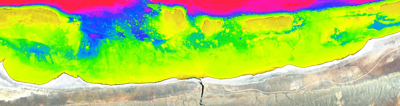
Hyperspectral bathymetry map of Ningaloo Reef derived from HyMap airborne data | 2009
Key Results and Impact
- Together, we successfully mapped 762 km² of the Ningaloo Reef environment to a depth of 20 meters, utilizing a semi-automated approach that delivered overall accuracies ranging from 70% to 84%.
- The results also revealed that macro-algae dominated 51% of the area, while hard and soft corals cover about 8% (58.6 km²).
- Including the coastal strip (up to 2km) was important as runoff from the coast can have detrimental effects on the corals.
Until today, we continue providing non-invasive, cost-effective technology to protect irreplaceable ecosystems.
Learn More
Read more about the project in these papers:
- Ningaloo Reef: Shallow Marine Habitats Mapped Using a Hyperspectral Sensor
- Bathymetry Derivatives and Habitat Data from Hyperspectral Imagery Establish a High-Resolution Baseline for Managing the Ningaloo Reef, Western Australia
- An assessment of coastal land cover and off-road vehicle tracks adjacent to Ningaloo Marine Park, north-western Australia
Follow along as we look back on two decades of progress, collaboration, and impact!
Contact
Reach out to Emily Twiggs in Australia or us at the HQ for any mapping solution you might need.
Latest EOMAP News

Reuters bases Mekong article on EOMAP data

UKHO’s highest-ranked Satellite-Derived Bathymetry provider in 2015

Mapping the ‘unmappable’ Great Barrier Reef

Dredge plume monitoring using satellite-based turbidity mapping

Pioneering seagrass mapping at the Italian coastline in 2006

Mapping Ningaloo Reef 2009: A Breakthrough in Hyperspectral Marine Habitat Analysis
Related Posts

07 / 2026
UKHO’s highest-ranked Satellite-Derived Bathymetry provider in 2015

06 / 2026
Mapping the ‘unmappable’ Great Barrier Reef

05 / 2026
Pioneering seagrass mapping at the Italian coastline in 2006

04 / 2026
20 Years EOMAP: Advancing Earth Observation

03 / 2026
New BD & Sales Manager for the Americas

02 / 2026
WATCOR‑X Bathymetry Software for Navies and Hydrographic Offices

01 / 2026
Bathymetry in the Gulf of Mexico

12 / 2025
From Climate to Nature and Biodiversity: Insights on COP30

11 / 2025
Projektstart SEAGUARD

10 / 2025
