𝗦𝗗𝗕 𝗨𝗽𝗱𝗮𝘁𝗲 𝗡𝗼. 𝟮 showcases the application of Satellite-Derived Bathymetry (SDB) in the crystal-clear waters of the Caribbean state.
NASA’s description of the Bahamas reads like poetry: ‘𝘌𝘢𝘴𝘵 𝘰𝘧 𝘴𝘰𝘶𝘵𝘩𝘦𝘳𝘯 𝘍𝘭𝘰𝘳𝘪𝘥𝘢, 𝘭𝘢𝘳𝘨𝘦 𝘢𝘳𝘦𝘢𝘴 𝘰𝘧 𝘰𝘤𝘦𝘢𝘯 𝘸𝘢𝘵𝘦𝘳 𝘨𝘭𝘰𝘸 𝘱𝘦𝘢𝘤𝘰𝘤𝘬 𝘣𝘭𝘶𝘦. 𝘛𝘩𝘦𝘴𝘦 𝘸𝘢𝘵𝘦𝘳𝘴 𝘰𝘸𝘦 𝘵𝘩𝘦𝘪𝘳 𝘪𝘳𝘪𝘥𝘦𝘴𝘤𝘦𝘯𝘤𝘦 𝘵𝘰 𝘵𝘩𝘦𝘪𝘳 𝘴𝘩𝘢𝘭𝘭𝘰𝘸 𝘥𝘦𝘱𝘵𝘩𝘴.’
The crests of this hilly underwater terrain form the islands of the Bahamas. The Great Bahama Bank, a massive underwater hill composed mainly of condensed carbonate sediments and ringed by reefs, dominates the view.

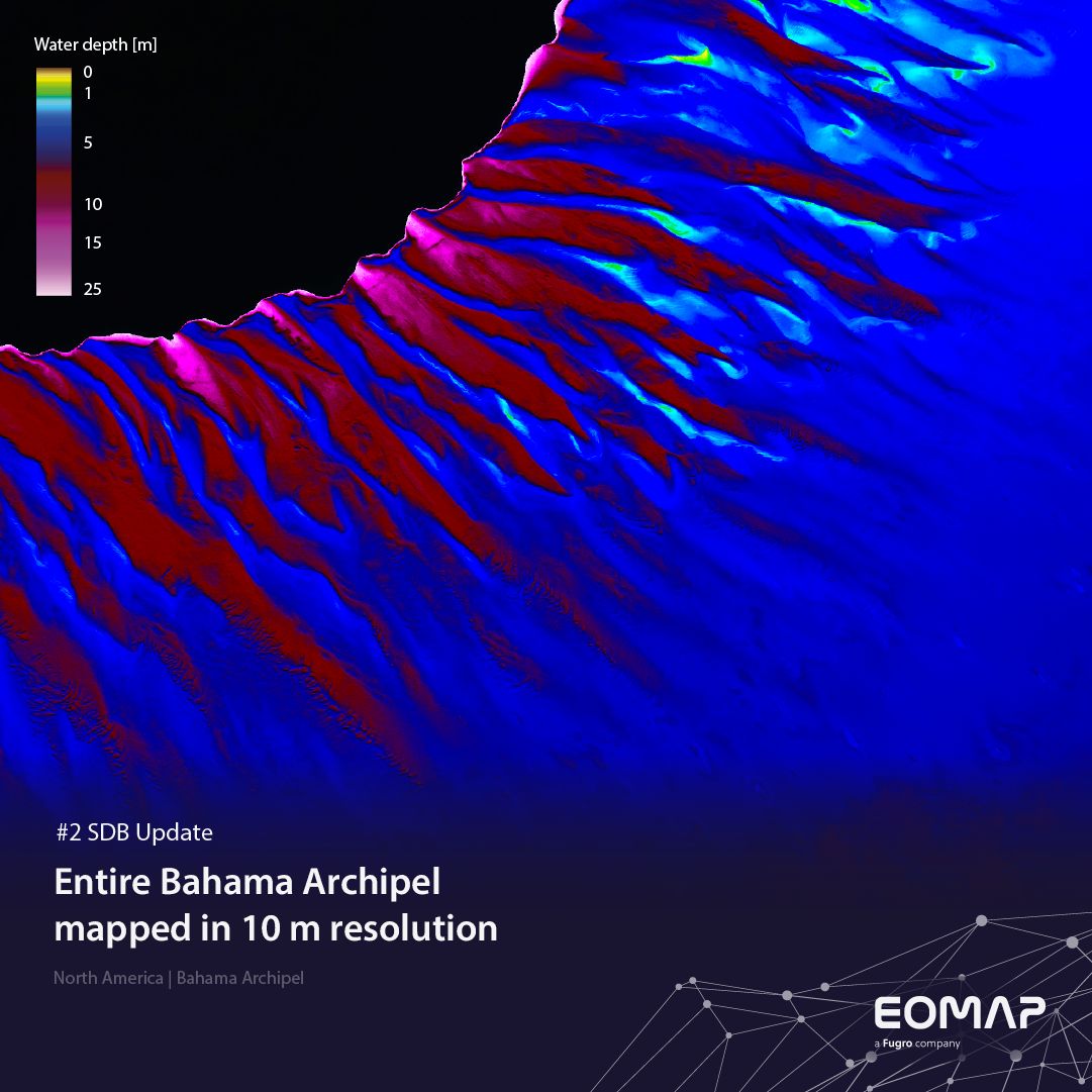
Satellite-Derived Bathymetry (SDB) of a central part of the Great Bahama Bank between South Andros and Exuma. The sharp drop in water depth is outlined in black.
Impressively clear waters
Despite hurricanes Milton and Oscar, the islands saw a record-breaking 11.2 million international visitors in 2024. Cruise tourism remains the key driver, according to Travelweek.
Across the banks, the water is often less than 10 metres deep, whereas the surrounding ocean floor drops dramatically to depths of 4,000 metres. The water’s clarity is amazing with Secchi Disk Depths of up to 40 metres – ideal conditions for SDB.
For this 10-m dataset, we analysed over 1,000 satellite scenes of Sentinel-2. These SDB results were validated using Satellite Lidar Bathymetry (SLB) with around 5 million data points from NASA’s IceSat sensor.
This dataset is useful for
- Managing this valuable ecosystem
- Understanding dynamics and both natural and human impacts
- Supporting safe navigation
10 metre resolution means that the smallest area mapped is 10x10m size – which is quite impressive for extended areas such as the Bahamas.
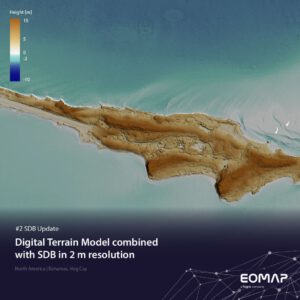
Hog Cay, in the southern Bahamas. EOMAP has combined SDB in 2 metre resolution with a Digital Surface Model (DSM) to a seamless topographic model.
However, for detailed studies – especially in coastal engineering and planning – we can increase the spatial resolution to submeter level of details (see Image 2). – Interested?
Contact
For other purposes – especially in coastal engineering and planning – we can increase the spatial resolution of SDB grids to submeter levels of detail. – Interested?
Please contact our US office or our SDB team for SDB services worldwide.
SDB update is a Linkedin post series on Satellite-Derived Bathymetry (SDB) by EOMAP – a Fugro company. Enjoy news, facts, and figures on a bi-weekly basis!
Latest EOMAP News

Reuters bases Mekong article on EOMAP data

UKHO’s highest-ranked Satellite-Derived Bathymetry provider in 2015

Mapping the ‘unmappable’ Great Barrier Reef

Dredge plume monitoring using satellite-based turbidity mapping

Pioneering seagrass mapping at the Italian coastline in 2006

Mapping Ningaloo Reef 2009: A Breakthrough in Hyperspectral Marine Habitat Analysis
Related Posts

07 / 2026
UKHO’s highest-ranked Satellite-Derived Bathymetry provider in 2015

06 / 2026
Mapping the ‘unmappable’ Great Barrier Reef

05 / 2026
Pioneering seagrass mapping at the Italian coastline in 2006

04 / 2026
Mapping Ningaloo Reef 2009: A Breakthrough in Hyperspectral Marine Habitat Analysis

04 / 2026
20 Years EOMAP: Advancing Earth Observation

03 / 2026
New BD & Sales Manager for the Americas

02 / 2026
WATCOR‑X Bathymetry Software for Navies and Hydrographic Offices

01 / 2026
Bathymetry in the Gulf of Mexico

12 / 2025
From Climate to Nature and Biodiversity: Insights on COP30

10 / 2025
