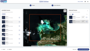
The new interface of SDB-Online
… will be live as of 21st June, the World Hydrography Day 2023.
The revamped Web App allows for mapping shallow waters even more quickly and easily. – Below the image, you will find more details on the new features, improved workflows and on how these will benefit you and other users.Access the new SDB-Online here.
Free Webinar
On the 6th of July 2023, we will walk you through the key improvements in a short webinar at 10 am CEST.
Please take the opportunity of joining us and getting all of your questions answered.
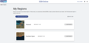
12 months access to unlimited processing
Once you have selected and purchased a region, the new interface offers you 12 months access to unlimited SDB processing of this region.
According to clients’ feedback and our own user experience, this is ideal for robust results and monitoring purposes.
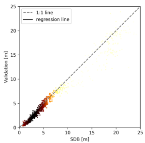 Calibration – Validation Feature
Refine your SDB processing by uploading own survey data. Quantify the accuracies and evaluate the results by validating the SDB result with your own survey data.
This is helpful to refine SDB results. Like many users, you might be impressed by the simplicity of this process and the robustness of the final data.
Read more on validation of SDB-Online data of shallow waters around the world.
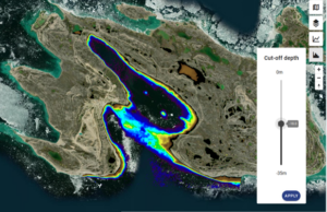
Cut-off depth
Define and apply a cut-off depth tool to clean depth noise, when post-processing your data.
This again, will entail time savings and more robust results.
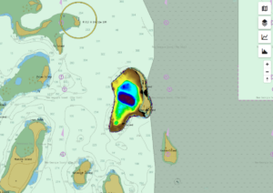
Nautical Chart Baselayer
Nautical charts are key to maritime safety, particularly in shallow waters. However, there are still uncharted areas in the oceans.
By switching between both views, this new feature offers you to compare SDB results with existing nautical charts.
 Reprocess multi-scene results and optimize ranking
Reprocess your multi-scene SDB result by selecting the best single satellite scene results or choose new imagery within few mouse clicks.
Eolytics SWIFT AOI: In addition, this tool allows optimized ranking of satellite-scenes based on individual areas of interest (AOIs). Use the integration of this full resolution Sentinel-2 image viewer within SDB-Online.
Both will offer significant time savings.
Credit system
Enjoy full cost control by uploading credits prior to your purchase. You are free to use them flexibly for your individual projects.
Contact us, if you wish to generate Satellite-Derived Bathymetry grids for your projects!
sdb-online@eomap.com .
Latest EOMAP News

Reuters bases Mekong article on EOMAP data

UKHO’s highest-ranked Satellite-Derived Bathymetry provider in 2015

Dredge plume monitoring using satellite-based turbidity mapping

Pioneering seagrass mapping at the Italian coastline in 2006

Mapping Ningaloo Reef 2009: A Breakthrough in Hyperspectral Marine Habitat Analysis

Advocating for Healthy Mountain Ecosystems
Related Posts

07 / 2026
UKHO’s highest-ranked Satellite-Derived Bathymetry provider in 2015

05 / 2026
Pioneering seagrass mapping at the Italian coastline in 2006

04 / 2026
Mapping Ningaloo Reef 2009: A Breakthrough in Hyperspectral Marine Habitat Analysis

04 / 2026
Advocating for Healthy Mountain Ecosystems

04 / 2026
20 Years EOMAP: Advancing Earth Observation

02 / 2026
WATCOR‑X Bathymetry Software for Navies and Hydrographic Offices

01 / 2026
Bathymetry in the Gulf of Mexico

01 / 2026
Pro-active hydropower management in winter

11 / 2025
Italian Webinar: Water Quality Monitoring from Space

11 / 2025
